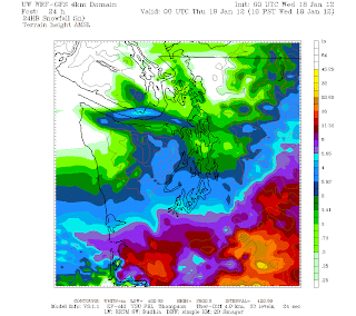
Here is a UW model projection of snowfall initialized at 4am this morning for a 24 hour time period ending at 4pm Wednesday.
If you look closely a few miles makes a huge difference in snow totals. Seattle is cut in half; points north of the University District will have less than 3 inches of snow and points south of there will have over 3 inches of snow. That is also if this model is correct which most of the time when it comes to snow for this part of town is difficult to predict; lots of variable terrain, and water that keeps our temperature hugging on to freezing. With that said, if the storm track drifts north about 40 miles Seattle will be in the red, if it really moves north we'll have plain rain. Another scenario is if the storm goes farther south and that spells cool and breezy, but not enough moisture for snow. Which is where the latest model is heading.
Here is a UW model snow projection initialized at 4pm.
The storm tracks a little further south moving the University District into the 2" range v. the 3" range for the time period of 4pm Tuesday to 4pm Wednesday. However there is room for more accumulation if the snow continues past 4pm. I just pulled from the UW model, but there are others out there with the same consensus of a light snow event. Remember though an inch of frozen precipitation can still wreak havoc on a city of hills.
Let's do a TV round up on what television station websites have on tomorrow's snow storm totals for Seattle as of 9pm Tuesday.
KOMO 4 Seattle Area 4-6"
KING 5 Downtown Seattle 3", Ballard 2", West Seattle 3"
KIRO 7 Seattle 4-6"
Q13 FOX Seattle 3"
These are all estimates that will probably change hour by hour with lots of uncertainty. Besides the storm track with the moisture factor in the second ingredient for snow. With temps hovering around freezing snow may fall later in the day but will it accumulate? How about adding the intensity factor. We don't have a major city center to our west to report what's coming our way, and the difference between moving over water and hitting land is huge. Your guess of a number between 2" and 12" is just as good as mine. So we'll all find out tomorrow after the storm blows by. I can tell you though that it is the wet snow variety.. the best for snowball fights and snow people. Enjoy whatever comes and be smart.

