Most of the Puget Sound area will remain dry today. The area of high pressure moving east of the mountains. The blue skies this morning will give way to clouds if you are not already under them. Rain? Sure. On the coast today and later tonight into tomorrow :)
Wednesday, October 19, 2011
Tuesday, October 18, 2011


Sun Drenched
Two words, east wind. That is the discussion amongst the meteorologists in Western Washington. When we have an east wind going it gets breezy in the Cascade Foothills and the temperatures will rise due to the sinking and compressing of air rolling down the Cascades.
So how warm will we get? Upper 60s to low 70s! Record territory. We'll be sun drenched for sure today... the next 30 to 100 days... well we dial into fall and rain drenched is on the other end.
Friday, September 30, 2011
A 70 Kind of Day
Update 12:30pm
RAIN. The cool air made it over with a burst of thunder and a short shower. Warm air rises; and with cooler air above and warm air near the surface, the warm air rising upwards, in order to moderate the temps, creates more clouds and once those clouds are saturated... rain! So the temperature reading will be lower than 70(F) but it will still feel like 70(F) with muggy conditions and a slim chance of T-showers and brief periods of rain. After the air above and below mixes enough and moderates that's when the rain stops; perhaps in the next few hours.
The showers are mainly around Seattle eastward, with a few heavy T-showers east of Tacoma (the red blob) and south of Olympia.
 --
--
The first rule of thumb before forecasting is... to look outside! And, with that note looking outside I did. Tilting my head to the north... blue skies, to the south... pockets of clouds moving in from the southwest. Very interesting. So here is the visible satellite image painting just that. Mostly blue and a few thin clouds north of Kent and scattered clouds south of Kent.(As of 10:30am PDT)
 These low clouds typically burn off easily during the summer but with autumn rolling in the clouds take a bit longer to dissipate and drift around. So right now partly to mostly cloudy skies will be mostly cloudy soon as more clouds are right off of our coast ready to swallow all of Western Washington. Yesterday's high temperature of 77(F) will not be reached today; it's looking more like a dry 70(F) kind of day. If you are making plans for tomorrow expect a dry start with rain moving in mid day and cooler temperatures. Sunday will be the winner this weekend with dry conditions.
RAIN. The cool air made it over with a burst of thunder and a short shower. Warm air rises; and with cooler air above and warm air near the surface, the warm air rising upwards, in order to moderate the temps, creates more clouds and once those clouds are saturated... rain! So the temperature reading will be lower than 70(F) but it will still feel like 70(F) with muggy conditions and a slim chance of T-showers and brief periods of rain. After the air above and below mixes enough and moderates that's when the rain stops; perhaps in the next few hours.
The showers are mainly around Seattle eastward, with a few heavy T-showers east of Tacoma (the red blob) and south of Olympia.

The first rule of thumb before forecasting is... to look outside! And, with that note looking outside I did. Tilting my head to the north... blue skies, to the south... pockets of clouds moving in from the southwest. Very interesting. So here is the visible satellite image painting just that. Mostly blue and a few thin clouds north of Kent and scattered clouds south of Kent.(As of 10:30am PDT)

Wednesday, September 28, 2011
And the Blog Kickstarts Again!
Hello friends! I fell off the face of the Earth for a moment and now I'm back. Wedding season is wrapping up, family vacations are a thing of summer, and days without school and classes begin. With some changes in my schedule I'm going to tweak Weather Bites! to weekend weather bites, and if I have time during the week pepper in some weekday bites and food. So hello again.
After tomorrow's (Thursday 09/29) gorgeous day, these beautiful sunsets on a clear day will become far and few between; our nights are getting longer and the air cooler. Before you know it we will have some snow in the picture :)
 And the Blog Kickstarts Again!
After tomorrow's (Thursday 09/29) gorgeous day, these beautiful sunsets on a clear day will become far and few between; our nights are getting longer and the air cooler. Before you know it we will have some snow in the picture :)

Thursday, August 25, 2011

Thursday, August 11, 2011
A Hot Shot
So no thunderstorms, no washouts, and well kind of boring weather still. Plain old cloudy mornings and a guessing game of when the sky will turn from grey and puffy to bright and blue. I'm going to attempt to make the last two days interesting... Tuesday was super cloudy where the sun was trying to make an early comeback by peeking through the clouds every now and finally minutes before sunset aaah ( that was suppose to be that one holy sound) orange light filled our living rooms; night fell and the clouds rolled back in. Wednesday was a day when forecasters called for a mostly cloudy day and drizzly. If you were present and aware of what was happening outside the sun was out in full force by mid afternoon. And, it was an actually a more sunnier day than Tuesday. I tried.
The bite of today is more or less of the same with most of us on the west side of the Cascades under the clouds. But if you look closely it a little bluish; with thinner clouds, heck, we might be sunny by noon! Since today is the perfect day, we'll go for a high of 75.
Copy and paste today for Saturday and Sunday, oh and we can't forget Friday... erase a little of the morning clouds and we have temperatures soaring into the mid 70s... oh my.
Now where did I get my title? Right.. with the few days of August left and a plain July the chances for hot days, i.e. days in the upper 80s and above are dwindling. With that said we might have a hot shot next weekend, Aug 20, 21. For four days a model painted one day of upper 80s and squeezed out a day in the low 90s. Those days are quite a ways away. So don't bet on it; considering this weekend looked more like this Friday yesterday, and today the weekend looks more like today. I feel a bit confused so I hope you get the last sentence.
Thursday, August 4, 2011

Tuesday, August 2, 2011
Stuck in Anoher Kind of Lull
Can you believe it? Some coined the weather in the Northwest this summer as bipolar. Especially since we'll have a day with high temperatures in the 80s followed by a day struggling to make it to the 60 degree F mark. I have to break the news to you folks... we are stuck in another kind of lull... a comfortable one:) In Western Washington expect brief morning clouds for some of the days and then afternoon sunshine, temperatures ranging from mid 80s in Southwest Washington, on either side of 80 in the Seattle Met Area, and a bit cooler as we head north ... for the next 16 days. I know, I know it is premature for me to make such a bold statement, but that is how it looks. Maybe some morning drizzle 10 days out from today.
Tim will be out with his gang for another game of dodgeball tonight. Where people sweat, grunt, and get dirty. The sun is setting earlier, at 8:42pm, so a sunny first half with temps around the 60s and then a cool, refreshing second half under the Denny lights. But, the cool air won't deter them because their adrenaline is flowing after being hit in the head and determination kicks in to smash their opponent and run them down to the ground. Today's high temperature for Seattle, 75. As of now there are clouds when you look out the window; they are quickly burning off leaving us with blue skies by this afternoon.
Tim will be out with his gang for another game of dodgeball tonight. Where people sweat, grunt, and get dirty. The sun is setting earlier, at 8:42pm, so a sunny first half with temps around the 60s and then a cool, refreshing second half under the Denny lights. But, the cool air won't deter them because their adrenaline is flowing after being hit in the head and determination kicks in to smash their opponent and run them down to the ground. Today's high temperature for Seattle, 75. As of now there are clouds when you look out the window; they are quickly burning off leaving us with blue skies by this afternoon.
Sunday, July 31, 2011
It Took a Minute
It's 2pm ... where's the sun Jim? It took a minute okay? The clouds started to break up around 2pm today in South King County and now as of 4:30pm most places that were under the clouds this morning in Western Washington is enjoying the sunshine with the exception of the Cascade Foothills, so give it another minute.
With the sun out temperatures are hovering around either side of 70 degrees F, I'm sweating in the Auburn Supermall parking lot. Time for me to catch some indoor mall AC :) Make it an awesome Sunday.
Friday, July 29, 2011
Another Sweet Weekend?

I took this picture just an hour ago and look outside now; clear skies. Or at least my window is showcasing blue skies. Another sweet weekend? I think so! Last weekend packed some heat; we added another 80+ degree day, and this weekend isn't getting that warm but confortable with temperatures in the mid to upper 70’s degrees F. If you want just a number I’ll give you 77 for Seattle and 82 for Vancouver, WA tomorrow. Early risers will wake up to some morning clouds, but if you have the luxury to sleep in tomorrow you’ll wake up to straight up sunshine. The clouds that roll in late Saturday however will drop our temperatures a few degrees on Sunday, and you have to wake up really late… around 2pm… to recover from Saturday night perhaps? to see completely blue skies outside of your window. Now 2pm is my estimate so don't quote me :)
Canoozing is a go go tomorrow as it will be the better half of this weekend.
Canoozing is a go go tomorrow as it will be the better half of this weekend.
Monday, July 25, 2011
Cooling Down
Yesterday at this time, 11am, Seatac was sitting at 73 degrees F and right now it's reporting 60 degrees with lightening in the distance; what a difference a day makes. We'll be hearing squeaky shoes today if you work in an office building as the ground is wet and the rain is falling. Here in the Udistrict the rain has been more of a sprinkle to rain the back to a sprinkle.
I haven't used this in a while. The showers are a bit heavy and are mainly concentrated around the Central Sound this morning.
Considering how cool and cloudy we have been Seattle is still below normal for July when it comes to rain measured in the rain gauge... but that will change today; we need to cover .07 inches of rain. Expect showers, some rumbles of thunder, and even some peeks of sun in between the clouds and showers.
I haven't used this in a while. The showers are a bit heavy and are mainly concentrated around the Central Sound this morning.

Considering how cool and cloudy we have been Seattle is still below normal for July when it comes to rain measured in the rain gauge... but that will change today; we need to cover .07 inches of rain. Expect showers, some rumbles of thunder, and even some peeks of sun in between the clouds and showers.
Thursday, July 21, 2011
Heatin' Up this Weekend!
Thanks Chelle for reminding me of my Weather Bites!

After what seems like weeks of uncharacteristic summer weather, and another week of it; people are feeling the summer blues but are seeing grey. My friends and family are asking me when summer is going start or when we will feel the heat. On our way to Red Mango today Pat and I noticed people are still bundled with jackets and hoods, rain boots, and lugging around umbrellas. Summer much? more like Autumn. We used the car's heater on our way back to simulate summer and complement our cold frozen yogurt and smoothies.
Let's reflect on July for the last five years by numbers to see if we actually are lacking heat this year. It was only two weekends ago that we had a stretch of 80 degree weather, which seems like eternity for some folks :)
These numbers were recorded at Seatac Airport and retrieved from the National Weather Service.
Year Days >= 80 degrees Average High Days w/Precip
2010 10 74.9 7
2009 18 81.0 5
2008 9 74.9 6
2007 10 77.4 9
2006 12 78.1 7
So far this July...
2011 3 73.4 9
According to the Average High we are about 'average' for this corner of the Earth because each day we have been topping off in the low to mid 70s, but what we remember summer by is the stretches of hot weather, and well... sunshine. With only 3 days at 80 degrees or above this July and only 10 days left in the month, we will definitely be below normal compared to the last five years in that sense.
Good news though, there's a chance to tack on one day to the Days >=80 degrees column for 2011 and if we're lucky... two days. This weekend we'll be heatin' up!
This is the 500 mb heights forecast for 5pm PST today. mb is a measure of pressure, and the heights indicate how high from sea level is 500 mb measured. So the greater the heights the warmer the air since warmer air takes up more space. Notice how the Northwest is under a shade of red and in the U part of a wave. That signifies lower heights/thicknesses translating to cooler temperatures and the U part is a trough which spells clouds and precipitation.


Today looks gross outside but is drying out as the day goes on with the exception of the Convergence Zone. We'll all get some peeks of sun before sunset. The bite for tomorrow; after morning clouds high pressure begins to settle in for afternoon sunshine.
Drum roll please for this weekend. And, put on your thinking caps for outdoor activities. Sunny and sunny up and down Interstate 5 with temperatures in the upper 70s to low 80s for the Seattle Area, low 70s near the Canadian border, and upper 80s around Portland for both Saturday and Sunday. That's all I have to write. What happens next is up to you :) I'll keep an eye on this 'heat wave' to see if it will fall apart when Saturday approaches.
Thursday, July 7, 2011
Grey Start
Or shall I say grey starts! After enjoying the 80s (temps, not the time warp) the Northwest is in for a cool down. It is summer after all, so I hate to type unseasonably cool weather. The brightside of unseasonably cool translates to temps in upper 60s which is comfortable for most folks; just not summer like; jackets in the morning to deal with drizzle and that is peeled off in the afternoon for the partly sunny skies; an onion kind of day.
The summer pattern in our corner of the earth has the strong jet further north into Northern B.C. compared to winter with the jet aimed right at us. Instead of having storms come head on, they veer north. Leaving us with the driest season and morning clouds here and there. It's sagging a bit this week. So the effect? More morning clouds, drizzle, and a chance of showers north of Seattle.
Tuesday, July 5, 2011
Wall to Wall Sunshine
If you liked yesterday's warm day we're in for a repeat. Today's high under blue skies, upper 70s and low 80s across most places west of the Cascades. The coast with the ocean breeze will be much cooler, 60s will be the high there. And of course the foothills... upper 80s. Tomorrow starts out the same but clouds roll in late evening similar to Saturday. Ahh, these days are refreshing as iced tea :)


Taken at 6:42pm
Sunday, July 3, 2011
Afternoon Sunshine for Sunday
The system was literally in and out. We saw clouds roll in late last night, and some showers here and there this morning. The mighty summer sun will bust through the clouds this afternoon leaving us with mostly sunny skies lasting into next week. And, temps will be on the cooler side with a warm up through next week.
Saturday, July 2, 2011
West Coast Sunshine!
West Coast Sunshine! From Baja California to the southern tip of British Columbia, Canada. That's something to celebrate with your sunglasses, short shorts, and sandals... where your toes can feel the warm breeze instead of cold water (unless you dare to step into the lakes, rivers, or seashores.) Tomorrow however spells clouds and cooler temperatures; the chance of morning drizzle is high with a strong onshore push when a low drives in to our north, the chances of rain for the rest of the day is less than 50 percent since the systems center will be hundreds of miles north of the Central Sound. Bellingham, which is closer, will have a better chance for rain. A repeat of Friday is in store for our Independence Day, woot woot Amerrrrica!
Finally congrats to my tennis man Novak Djokovic. I have been following his game in the early days when he wasn't a well received player because of "arrogance." I thought he was a young, confident player that is having fun with the game. Check out his hilarious impersonations of Maria Sharapova and Rafael Nadal from the 2007 US Open.
Roger Federer and Rafael Nadal has dominated the Number 1 spot since February of 2004 on the ATP World Tour. Djokovic cracked the top ten in April 2004 and has been bouncing between the Number 4, 3, and 2 spot since July of 2007. Tomorrow will be a battle at Wimbledon between the current Number 1, Rafael Nadal, and the future Number 1 player come Monday's new ranking. Please welcome the new World Number 1 Tennis Player Novak Djokovic.

Djokovic, Ascendant, Prepares to Confront Nadal, a NYTimes article to be pubished in the July 3, 2011 paper.
Weather Update 3:44pm
SeaTac is sitting at 79 degrees F. It has been 301 days since Seattle (which is actually SeaTac) has reached 80 degrees, which is the 4th longest streak on record, the longest 319 days in 1960. You can read about that in Scott Sistek's blog. It might turn out like the uneventful day this year that Seattle ended it's streak of 70less days by hitting 70 degrees for mere minutes!
Currently in:
Bellingham 74
Mount Vernon 73
Boeing Field, Seattle 79
UW, Seattle 74
Olympia 80
Chehalis 82
Hoquiam 62
Portland 83
Eugene 81
Weather Update 10:44pm
The streak ends at 301 days without an 80 degree day. Temperatures rose to 82 degrees F at SeaTac.
Friday, July 1, 2011
This Weather Does NOT Bite
Some woke up to clouds, some straight up sunshine. And for today and tomorrow everyone will catch some rays in the Pacific Northwest with temperatures ranging from the upper 60s near the coast, low 70s around the metro and mid 70s inland. Sunday... is down right cloudy. Monday dry, warm, and surprisingly nice for a July 4th, historically the wettest day in July for Seattlelites.
Thursday, June 30, 2011
June Gloom.. Auf Wiedersehen
The shower chances are limited to areas northeast of Everett stretching towards the foothills of the Cascades. Satellite loops show thin broken clouds off the coast, and that is giving us pockets of blue skies. If you look outside you a see a few of those pockets and later this afternoon well have bigger pockets of blue ( if not mostly blue by this evening.) Even with some partial clearing, high temperatures will still be below normal.. in the low 60's for Western Washington. The last bit of June gloom isn't looking to shady after all.
Wednesday, June 29, 2011
Unexpected Sushine
Mostly cloudy and showers is the theme for today and tomorrow as a system is moving towards British Columbia. The sun was out in the Green River Valley this morning and now this afternoon over Seattle north to Shoreline and east over Elliott Bay for beautiful outdoor pictures. If I had a boat this pocket of sunshine and breeze is great for sailing. Places near the Cascades are hogging all of the showers so far. Considering today was suppose to be more showery than tomorrow, I'm going with a bite of mostly cloudy and mainly dry with a few showers for tomorrow, the last day of June gloom.


Tuesday, June 28, 2011
Fizzling June and a Normal July
All signs pointed to a beautiful, sunny Monday as forecast after forecast had winds coming in from the east, which provides a drying and warming effect for the Puget Sound and areas west of the Cascade Range. I saw Alex in shorts and sunglasses anticipating for the afternoon sun routine.. nope, didn't materialize. The air temperature was a cooler than Sunday but their was a muggy feel in the air as the winds came from the south, bring warm, humid air. June will fizzle out in the tune of below normal high temperatures and at or above precipitation norms.
The bite today cloudy skies and a fifty percent chance of rain, similar to Monday but less humid and cooler for the next couple of days. Enough about June, how about July 2011.


These are preliminary outlooks dated on the 16th of June 2011. With La Nina out of the picture this summer is looking quite normal with around normal high temperatures and precipitation for the Northwest. I'll post the updated outlook when that gets in. July 1st is looking dry with morning clouds, afternoon sun and temperatures around...normal?!
The bite today cloudy skies and a fifty percent chance of rain, similar to Monday but less humid and cooler for the next couple of days. Enough about June, how about July 2011.


Update 1:30pm
It's still a bit muggy at 71 degrees F and 68% humidity at Seatac compared 78% a few hours ago, but the wind is shifting more westerly drying the air a little, which is ironic because it is off the ocean. However the westerly winds off the Pacific is an air conditioner giving us the refreshing, cool air with less moisture content that the southerly winds which has the combination of tropical moisture and warmer air which has more water content and the mugginess. The chance of rain is practically gone, leaving us with hazy sunshine and comfortable temperatures. Enjoy the rest of your day. Monday, June 27, 2011
Flip flops, Seattle Weather, and Wet Sidewalks.. BEWARE!
Early summer mornings in Seattle translate to wet sidewalks from dew and warmer temperatures for flip flop wearing conditions. I'm fairly aware of my surroundings, I look left and right before crossing the street making sure the walk light is on. I am afraid of stepping on dog poop so every step is carefully made. But, today was a different story. Maybe I was still sleepy after spending seven hours flying (yes my carbon footprint this year will be astronomical.) Or daydreaming because I always manage to do that.
This one step out of my 22 years, 10 months, and 15 days of existence made me stop in my tracks. I did the scary movie pose where something or someone is coming but I am dead in my tracks... staring and screaming. Let me remind you I was sporting my flippy floppys and the sidewalks were wet. What did I step on??? My mind freaked out and I don't even remember too much of how or what happened. This is what's left of my shattered memory of this morning...My toes felt wet as a body was strewn across my big toe, I had orange goo and guts on my foot. From the pattern on the skin, I realized that..I stepped on a slug or shall I state stepped on and acrobatically burger flipped it onto my toes...how the heck did the body flip up and explode on top of my toe and foot? Just thinking about this makes my skin crawl.... after a moment of shock I gathered my marbles and walked five blocks to my final destination. Why didn't I go caveman and wipe off the slug juice with a leaf? I waited until I reached the restroom with running water.
I tell myself now that the slug had already died and I happened to add insult to injury. And, instead of dying peaceful in someones garden the final resting spot was the sidewalk. This slug is being remembered and has left a legacy on this blog.
My mistake can be a lesson learned for others. Flip flops, Seattle weather, and wet sidewalks. The result.. wet toes, guts, and shock. Beware!
Tuesday, June 21, 2011
Summer has Arrived!
Sunrise 5:11am
Sunset 9:11pm
Length of Day 15h:59m:29s (provided from timeanddate.com)
Right on cue the sun is shining in the morning up and down the West Coast and will shine until the sunsets at 9:11pm! Forecasted high temps today are in the mid 70s for the Seattle Metro Area. Today's sunshine however is short lived as the clouds increase and temperatures dip through out the week; yep, below average, which average for this time of the year climbed to 72 degrees F. Tourists in the Northwest, this is a taste of summer because the "unofficial" start of of summer is July 5th. Scott Sistek at KOMO has kept up an odds it will rain chart, and for the past 117 years of record keeping July 4th is the wettest day of July for Seattle before trending dryer, with the driest period in Seattle from mid July to mid August.
I will be in Montreal for the next week. So the next update will be on Monday. Make it a great week.
Saturday, June 18, 2011
In to the Deep End
From Spokane west to the Pacific Ocean everyone had a glimpse of the golden orb before the high clouds took over yesterday. We have been stuck in a morning clouds and afternoon sun pattern for a while, coupled with cooler than normal temperatures and occasional overnight showers.
Today will feature hit or miss showers decreasing by the time we head into the evening hours. So far SeaTac has recorded 0.26 inches of rain and here in the Udistrict 0.10 inches of rain. Hit or miss showers can really dump and soak a place for an hour or so in one area while a neighboring city would be sitting under dry, cloudy conditions.
I have two maps to show you from the NWS. Here is the forecast for today's high temps. 62 degrees F! That's 8 degrees below normal for this time of the year. And, look at our mountain ranges; parts of the Cascades and Olympics are below freezing for daytime high temps. The snow level is above pass elevations so driving will be fine today as in precipitation of the liquid kind; still be cautious though there's low lying fog, pockets of heavy rain, and mist.

After today's dive into the deep end and struggle to reach the low 60s, and tomorrow's mostly cloudy but dry day; we'll gradually return back to the morning clouds and afternoon sun routine starting Monday with temperatures rebounding to the upper 60s. And right on cue when summer does arrive officially, it unofficially happens in the Northwest by July 5th (I'll blog about why in a couple of days,) models are pointing towards partly to mostly sunny skies. Seattleites and Portlanders will be comfortably in the mid 70s under the sun.

Monday, June 13, 2011
The Joys of Breakfast

Challah French Toast with Roasted Apricots and Honey-Vanilla Creme Fraiche a fancy name for a fancy breakfast with bacon. The sun was shining right above us as we all enjoyed this delicious treat outside. Yes, I love to brag every once in a while. And, guess what... I have the privilege of tasting everything on the blog pastryprose.blogspot.com.
With food aside, the weather in the Northwest; or shall I write, 'up and down the west coast' is still stuck in a lull. Californians are experiencing morning clouds and afternoon sun... they call it June gloom. We on the other hand are experiencing mostly cloudy skies, dry, with a few spot showers, and partial clearing in the afternoon sometimes. What would they call that? My best guess would be.. Winter.
The June 1st post touching upon the the below normal temperatures is holding true with temperatures running a few degrees below our normal of 69 degrees F for the next couple of days. The bite for Monday, Tuesday, and Wednesday... a strong push of marine air each day may squeeze out some showers along with cloudy skies, and if the layer isn't too thick we'll see a little sun in the afternoon.
Update 12:45pm
We have some sun in spots and rain in a few locations right now and drizzle or light rain all around Western Washington this morning. This means two things. Our air is super moist and with the sun we have the potential of warming up the air near the surface. These two main ingredients causes instability and rain showers. Warm air near the ground wants to rise and cool off and when that happens convective clouds form. With super moist air the cloud is concentrated enough for rain showers to fall. So don't be surprised if you are caught under one. On a side note the familiar Puget Sound Convergence Zone has a chance of forming North of Seattle this evening. Where ever it drifts it will drop steady rain.
And, winds.. it is a bit breezy outside with winds gusting to 20 mph in the Central and South Puget Sound areas. This is because of a pressure gradient where the high pressure wants to go to the lower pressure, kind of like river water and a waterfall. The higher the water the greater the fall to the lower part of the river. The difference is about 2 hPa higher at the coast than the Puget Sound right now, translating the breezy winds from the southwest (true west winds are rare in the Puget Sound area because of the massive Olympic Mountains.)
Friday, June 10, 2011
Dodgeball!

Wednesday, June 8, 2011
Stuck in a Lull
I'm kind of a boring person, and people talk about weather when there is nothing else to talk about.... So what does that make of me? Especially since it's June time in Seattle... a very blah kind of month weatherwise. We are transitioning out of the active spring weather to more of a lull. Storm systems are weak and high pressure is not in full gear yet.
The influence for the next several days is our neighbor the Pacfic Ocean. With each morning we get a marine push. The larger the push, the thicker the clouds, the cooler we are and maybe we can squeeze out some rain. The lighter the push, the thinner the clouds, more sun in the afternoon leading to a warmer day. So high temperature wise will be bouncing on either side of normal which is 68 degrees f. To me that's borrrrriiinng.
The bites sunbreaks this afternoon to mostly sunny by 8pm, a weak push tomorrow, and a strong push on Friday.
Monday, June 6, 2011
Squeezing Sun Drops
We have areas of clouds and peaks of blue sky so the sun is shining somewhere in Western Washington. I'll make this short... Mainly dry and if this cloud model pans out we'll squeeze out some more sun later this afternoon with partly to mostly sunny skies. Click on the image below to see you are in the clear. This is for 5pm today.

Sunday, June 5, 2011
Clouds are Back
It's 12:30pm on Sunday and the clouds are back over half of Washington and all of Oregon. Lynnwood northward is enjoying blue skies for the time being but look southeast not to the west for clouds to roll in. Hazy sunshine to mostly cloudy skies is in store for the rest of today coupled with warm temperatures moderating around the low to mid 70s and much cooler near the water.
Saturday, June 4, 2011
First Food Post :)
Fridays are days when I am grumpy and sleep super early My theory behind this is that by the end of the week my body catches up with me, and without school or work the next day my body is permitted to shutdown for some r&r. I was reluctant to go to happy hour but after winning two games of shuffleboard back to back, a late evening nap, and some convincing by my cousin Kay I slid into my flip flops and was out the door. First stop was Ivar's Salmon House. They have hh for the big kids from 3pm to close in the lounge and on sunny days on the water. Great food with great company and a view... however the one hour wait was a little much. Next stop Joey's on Lake Union.... same problem. It's Friday evening.... where to go... Palomino! Located in Downtown Seattle parking can be a pain. They have complementary 2 hour parking after 5pm on weekdays and the restaurant has a spacious lounge for happy hour from 3pm to close.

For food we ordered two pizzas; one pepperoni and one italian sausage and mushroom. The delightful thin crust treats came out hot and not too greasy. Pep was a little on the salty side but pair it with a beer or cocktail and it is phenomenal. If you like a little spice to your sausage, which I do, the italian sausage and mushroom was definitely a win. The draught beer for the both of us was Guinness Stout.
The total for tonight..$22.00 for two beers ($4 each), two pizzas ($6 each) and Seattle tax. This was my first time here and I would definitely come back to try new menu items.
Friday, June 3, 2011
Sweet Weekend Forecast

Wow. The sunniest, most comfortable weekend forecast since September 2010. A pair of 70 something degrees weather two days back to back and the high temperature for today is near the 70 degree mark making it three days in a row if we do reach that milestone. We did hit 70 once this year at SeaTac for maybe one or two minutes but this time around we can bask in the 70s. Man can I keep this up and write 70 in every sentence? Nope.

This picture was taken yesterday after walking the shuffleboard champion Alex, to the bus stop. I do have heartbreaking news for sun fans though. That picture above of cloudy skies will return soon; the sun will go away as fast as it came so make it a great weekend with friends and family and pollen and bugs and books.
Thursday, June 2, 2011
One More Wet Day
Today's bite...one more wet day for some while others squeak by with a mostly cloudy day and chilly day. High temperatures will struggle towards 60 degrees and may fall short. Bellingham and the North Sound will take first place in who can catch the most rain competition as the model paints those areas with rain showers in the morning lasting into the night. Seattle will see increasing rain starting around noon with showers lasting until midnight.
Friday is going to be the typical Northwest summer of morning clouds and afternoon sun and temperatures... believe it or not...slightly above the normal of 67 degrees!
This weekend jumps from Friday's typical summer to 'this is why we put up with 9 months of soggy weather' kind of day. GFS Model Output Statistics(GMOS) from the NWS has clear skies and 78 degrees for Saturday and partly cloudy 78 degrees for Sunday. Yesterday's model run had the two days at 80 and 82 degrees so it did back up from the warming a bit. This is a sweet taste of summer.
My friend Nancy and I summed up our summer to be with... hiking trips, recipe testing on the grill, cold beers,... ummm those activities will have to wait until after my studying time.
Wednesday, June 1, 2011
Ahoy! June Outlook
Today is the start of a new month. So what's the outlook like? Below normal temperatures and above normal precipitation. "Whine, whine, whine" ... a phrase pulled from the house jargon and bro quotes developed by my lovely roommates with this kind of June. The bright side; below normal in early May was a high of 52 degrees F and a normal of 62, yes chilly and burr for below normal. In late June the normal high is 73 degrees; so I can take 66 or 72 because those are below normal and still comfortable! Here is the NWS Climate Prediction Center's June 2011 high temperatures map. Blue indicates below normal, orangy colors above normal, and white is about normal.


Precipitation chances for June are above normal. The bright side June is the third driest month for the Pacific Northwest.
I can't however find a bright side for sunshine hours because usually precip come with clouds. So maybe more sunshine than our cloudy, cool, wet March, April, May works?
Tuesday, May 31, 2011
See You Later May
Filming today in Seattle? You can grab its weather essence on tape like Sleepless in Seattle or television show Grey's Anatomy on this cold and dreary day. After a pleasantly dry Memorial Day, rain returns as a farewell gift from our chilly, wet May. This gift lasts into Wednesday and Thursday before June gets his head straight on the third.
The details... Steady rain this afternoon with a chance of thunderstorms near the Cascades. If we're lucky we'll have a storm drift into the lowlands for a bang to the last of May 2011. Tonight will feature showers and clouds to ring in the new month.
Wednesday and Thursday outlook... Getting more dry each day with plenty of showers tomorrow and increasing dry times for Thursday.
Check back for the weekend bite for temperatures. Models have it a bit toasty for me to put my hopes up. Regardless Udubians will be in study mode with another element of distraction.. sunshine!
Update 3:50pm
We have all around conditions right now. Partly sunny skies in Bellingham, Seattle's U district, Arlington, Port Angeles. Raining at Paine Field in Everett, McChord Field Airport, and Puyallup. This base reflectivity image tells all.

Friday, May 27, 2011
Sunglasses and Raincoats
Sunglasses and raincoats, what a combination... the weather today is a 'don't like what's happening outside? Wait thirty minutes.' Rain showers grazed Downtown Seattle earlier and a bit north at the Seattle Center dry! Right now as of 12:24pm sunny in both locations!
That's going to be the bite for today and tomorrow. Spring in the Great Pacific Northwest.

Thursday, May 26, 2011
Pockets Full of Sunshine
Here's a super catchy tune Natasha Bedingfield's Pocketful of Sunshine
And today's bite. Do I have to say anymore than sun breaks, clouds, showers, and cooler than normal temperatures?
 This satellite image reveals it all. Right now in the Udistrict blue skies in that pocket full of sunshine. The whitish stuff is clouds so if it's potent enough rain will fall. Looking at the models, showers are out of the metro area until late this afternoon for the drive home.
And today's bite. Do I have to say anymore than sun breaks, clouds, showers, and cooler than normal temperatures?
Wednesday, May 25, 2011
Tornado Frenzy
Cold in the Pacific Northwest coupled tornadoes on the other side of our country, that has been in the happening this 2011 year. Over the weekend Saturday's highs struggled to reach the low 50's about 10 - 16 degrees before normal and over this weekend one of the most deaths from a single tornado occurred in Missouri. And, yesterday Kansas and Oklahoma felt the brunt of the storms. I will dig up some data this weekend, but in the meantime Cliff Mass has a post on his blog about why that happens.
The bite for today with that slow moving low, I mean slow as it will park next to the Pacific Northwest, will bring temperatures 5 to 10 degrees below normal in a chilly, showery, and sun breaks pattern after the initial steady rain later this afternoon.
The bite for today with that slow moving low, I mean slow as it will park next to the Pacific Northwest, will bring temperatures 5 to 10 degrees below normal in a chilly, showery, and sun breaks pattern after the initial steady rain later this afternoon.
Tuesday, May 24, 2011
Today.. The Beautiful Tomorrow
Yesterday I wrote 'the beautiful tomorrow' and today is tomorrow. So where is the sun shining? Well at noon SeaTac, Port Angeles, and Orcas Island to name a few spots reported clear to scattered clouds. Let's take a look at the IR image of the West Coast.

The low pressure system that was giving us clouds and showers this past weekend is now over Colorado and right on queue another low pressure system is lurking off the coast of Washington and Oregon bringing rain tomorrow. So practically we are in between storms today giving us a mainly dry day with lots of sun breaks if not full sun by late this afternoon. Enjoy it as it is one of those rare May 2011 days where temps may climb above normal (by 1 degree f.)
Monday, May 23, 2011
Transition Day
Showers are roaming around Eastern Snohomish County and the rest of Washington is dry. That's going to be the picture; mainly dry, very few short lasting showers, and more sun breaks than yesterday as this is a transition day to a beautiful tomorrow.
Saturday, May 21, 2011
Out of theTurtle Shell
Today is when it starts; Seattlelites leaving their turtle shells called home and waking up from hibernation. Yeah, we did have people flocking outside the past few days to bask in the sunshine, but now people will come out rain or shine. Why is that you say? The answer is.. it's the start of the Festival and Fair season! The first one is the University Street Fair this weekend. The Ave will be loaded with food, crafts, and... pale people :)
Also in the happenings today is Quadstock, a music festival at Seattle University, and Relay for Life at Husky Stadium. Wet pavement and cloudy skies above may dishearten some moods, but hey you live in the Northwest.. embrace it. Shower activity this morning from the onshore flow is pushing northward leaving most of Western Washington dry. The bite calls for a mainly dry day and sun breaks. If it does shower a bit it will not last.
Also in the happenings today is Quadstock, a music festival at Seattle University, and Relay for Life at Husky Stadium. Wet pavement and cloudy skies above may dishearten some moods, but hey you live in the Northwest.. embrace it. Shower activity this morning from the onshore flow is pushing northward leaving most of Western Washington dry. The bite calls for a mainly dry day and sun breaks. If it does shower a bit it will not last.
Friday, May 20, 2011
The Grand Finale
Alright folks today is the day we find out if an old record, the latest 70 degree reading in a year, will be broken. Right now it is 49 degrees F and yesterday at the same time it was 46 degrees and it warmed up to 68 degrees at SeaTac. So we have a couple of degrees head start, but depending on how strong our seabreeze is it may only hit 69 degrees!
Shorts, sunglasses, sun tan lotions, sandals yes! enjoy it while it lasts today as it is the grand finale. The long range models isn't promising any warmer than normals days. I do see a couple of dry days peppered in within the showery days though. Relay for Life participants check out the bite tomorrow and find out when the radar lights up.
Update 5:00 pm
It did hit 70 degrees today at SeaTac; the old record stands at May 23rd.
Thursday, May 19, 2011
Warming Up
Two down two to go... as in two days left of full sunshine in our sunny and dry streak. Four days of sun seems unheard of and unusual with our track record of showers and below normal temperatures for the Pacific Northwest region this year. On Tuesday the thermometer dipped to the record low of 39 degrees F, and places in the South Sound reported frost! Those showery days all seem distant now when we are regularly waking up to sun :) jk.
The bite. Sun, sun, and more sun. With our air mass still cold, mornings and nights will be chilly, however with the sun as strong as late August the day will warm up nicely. And, yes if you would like a Seattle tan today and Friday will do it. Like I wrote earlier, the best chance for a 70 degree day is Friday and for the weather geeks if that temperature is not reached in Seattle, 2011 will go down as the latest first 70 degree reading; the latest date is May 23 according to Scott from KOMO and the models are definitely pointing to cooler weather for the next couple of days.
Here is one of the models with 4km spacing for Friday May 20th temperatures at 5pm.

Seattle is covered with the pink stuff but if a sea breeze kicks in the thermometer may be teasing us with 69 degrees. Regardless, 71 degrees or 69 degrees both feel the same to me :)
Tuesday, May 17, 2011
The Roof is Off
As for today M's fan will be delighted as the roof will be off tonight. It's still spring so with the sun dialed down a bit, the first pitch at 7:10pm does require jackets. Paige E.'s birthday should be the unofficial start of better weather; when clears days and sunny streaks are longer than the rainy and cloudy streaks. Happy birthday.
Sunday, May 15, 2011
Above Normal
Hmm high temperatures have been below normal and that has been the typical theme for this spring. How about being above normal? Check. The average rainfall for May is about 1.70 inches, and that was reached in two days coupled with daily rainfall records at SeaTac for May 14th and May 15th. That's however typical for a La Nina pattern in the Northwest. Cool showery weather and wetter than normal. The chances of snow in the lowlands is elevated but this year we it was a real hit in some places and miss in others; not to name any names...Seattle.
You know what else is typical; this cool, showery, and wet weather should come to and end soon. And, this will be exhibited in a couple of days from now...I hope.
Sticking to the topic of above normal how about that 70 degree day in Seattle? Friday. I'm being a bit optimistic as most notable weather sources have Friday at 69 degrees :) The weather is always changing so we'll count down and see what happens.
Friday, May 13, 2011
Sunny-ish
Blogger had a super long outage, so quick recap of yesterday; hail around the Kitsap Peninsula and sun in the Udistrict. Some place had hail and showers others place such as Kent and Bellevue remained sunny and dry.
As for today we are near the end of the sunny chapter and about to begin a new story late tomorrow and into Sunday. See the swirl of clouds over the Pacific due west of Washington and south of Alaska?
 That's an area of low pressure that was close enough to push high clouds over the Pacific Northwest for a sunny-ish day, but far enough for us to stay dry. The low will slide SE into Oregon bringing rain into the picture late tomorrow into Sunday.
As for today we are near the end of the sunny chapter and about to begin a new story late tomorrow and into Sunday. See the swirl of clouds over the Pacific due west of Washington and south of Alaska?
Thursday, May 12, 2011
One Day Rain Streak
Yesterday was definitely a cold wet one with almost half an in of rain reported from SeaTac and a high in the low 50s. Yuck. To make up for such a cold today we have a mostly dry day on tap with sun filtering through the clouds this morning in the Udist. Will it last? In the radar there are a few light scattered showers in the North Puget Sound area and off the coast the radar shows cool popcorn clouds. Looks like a one day rain streak.
This is a recipe for a mostly dry partly cloudy day with a few shower hinting arrival around the afternoon commute for Bremerton and Seattle stretching to the southeast. But, check back to see if that materializes. As for temps with the sun as strong as late August, any sun peak with warm us up; definitely warmer than yesterday.
Tomorrow Sun.
Wednesday, May 11, 2011
Chasing Normal
Is anything or anyone normal? That is a lengthy discussion to be had. In the weather world there's an almanac that keeps track of daily and monthly normals for us and guess what... we are starting another month with below normal high temperatures. So far we had two days at or above the daily normal. May 1st is the day we were a whooping 1 degree F above normal at 62 degrees at SeaTac, our official record keeping site for Seattle. The daily normal jumps to 62 degrees on May 2nd and slowly increases to 67 degrees by the end of May. Which in the near future seems unobtainable, but we are caught up to April's normal high temperatures :)
 The one month outlook for May 2011 from the National Weather Service has a big old B for below normal over the Pacific Northwest stretching east. These are probabilities and it seems like the first half of May is deserving of a B. Sun and warm weather lovers please don't be discouraged, there will be nice days peppered in I promise.
The bite for today. Cold rain. No joke. After the cold frontal band of rain passes this afternoon cooler air and showery weather from the Gulf of Alaska will follow. Tarps is a must for those with outdoor activities.
The bite for today. Cold rain. No joke. After the cold frontal band of rain passes this afternoon cooler air and showery weather from the Gulf of Alaska will follow. Tarps is a must for those with outdoor activities.
Sunday, May 8, 2011
Happy Mother's Day
Looks like all of Western Washington is in the belly of a cloud toad that ate us, but we'll be spat out soon. Today is a repeat of yesterday with periods of sun and periods of clouds.. one change mostly dry. It was pouring in Kent yesterday and today sprinkles are hanging around the South Sound; in the Auburn, Federal Way, and Tukwila area right now. That will be wrung out by the Cascades in a bit. Planning an outdoor bbq or a stroll with mama? Do it. Happy Mother's Day!
Friday, May 6, 2011
Flip Flops
My old pair of flip flops are worn out to the max and so I'm shopping for a new pair of flip flops for the next stretch of sun and warm weather. Doesn't look like we'll have a nice stretch in the near future, but we can only hope. This pair is called 'Waldo' at Nordstrom. The colors are a little much for my age, maybe I'll go for more neutral shades?

The weather is sporting flip flops of its own nature. Yesterday we had rain early in the morning and a mostly cloudy afternoon with showers. Flip flop 1: we'll have a mostly cloudy morning with showers and a wet late afternoon. Flip flop 2: Another weaksauce front? Nope, a front that has been lifting... :) With cold fronts, the cold dense air pushes nudges the warm air causing the warm air to rise or 'lift' from the surface. When the rising air cools and condenses clouds form and then precipitation.

The weather is sporting flip flops of its own nature. Yesterday we had rain early in the morning and a mostly cloudy afternoon with showers. Flip flop 1: we'll have a mostly cloudy morning with showers and a wet late afternoon. Flip flop 2: Another weaksauce front? Nope, a front that has been lifting... :) With cold fronts, the cold dense air pushes nudges the warm air causing the warm air to rise or 'lift' from the surface. When the rising air cools and condenses clouds form and then precipitation.
Update 8:30am
It's been raining at the Bellingham International Airport this morning with a whooping 0.31 inches in the gauge in the past 6 hours. Over the Udistrict nil at SeaTac International Airport Trace. But, that will all change this afternoon. Let's see who get the most precip in the next 12 hours.Update 3:45pm
Steady light rain is moving into the Puget Sound area, and will continue until late tonight. Chinatown this evening? I'll bet on more wet than dry.
Thursday, May 5, 2011
Weaksauce Front
After a warm sunny day the clouds, showers, and cooler than normal temperatures return to our area. The sunny stretch is at best two days so far this season for Seattle. I wonder when I can blog about three straight days of sun, but for me that would be less interesting weatherwise :)
A weak cold front from the system heading into British Columbia grazed Washington and Northern Oregon and dropped enough rain to wet the ground but not enough to water the plants. Yes, weaksauce. Rain fell in South Seattle from 5am to 6am and it looks like the precipitation is banked up on the Cascades leaving us with a mostly cloudy day.
This is an IR image for the Eastern Pacific at 8:30am today. The pink signifying the cold cloud tops which is thick in depth and may produce precipitation. This morning's front is now over Eastern Washington.
 You can see the swirly like system in the Pacific that is heading into BC and setting up a similar situation where we are grazed by the front but this time instead of a quicky this system is expected to linger, maybe has enough punch to actually water the plants, and will roll in late in the day. Check with me tomorrow for developments.
A weak cold front from the system heading into British Columbia grazed Washington and Northern Oregon and dropped enough rain to wet the ground but not enough to water the plants. Yes, weaksauce. Rain fell in South Seattle from 5am to 6am and it looks like the precipitation is banked up on the Cascades leaving us with a mostly cloudy day.
This is an IR image for the Eastern Pacific at 8:30am today. The pink signifying the cold cloud tops which is thick in depth and may produce precipitation. This morning's front is now over Eastern Washington.

Wednesday, May 4, 2011
Sun! Check!
Wow. The sun made a comeback after two days of clouds and rain. What have we been dealing with this winter? Let's recap, the coldest April of all time (high temperature wise), 40+ consecutive days without an official sunny day, a huge snow storm that did materialize not over the metropolis but 40 miles north of Seattle dumping 3 feet of snow, and we're still waiting for that 70 degrees F day.
We're moving down the scale from weeks in between for sun to days. Then again Seattle is has the most overcast days for a major city, 220. But, hey within the first four months in 2011 we had 83 cloudy days; so maybe more sunny days on tap? With that said when summer rolls around the new tag line would be 'where's the rain the clouds'?
 With highs in the mid 60s today relax and have a float :-)
We're moving down the scale from weeks in between for sun to days. Then again Seattle is has the most overcast days for a major city, 220. But, hey within the first four months in 2011 we had 83 cloudy days; so maybe more sunny days on tap? With that said when summer rolls around the new tag line would be 'where's the rain the clouds'?

Tuesday, May 3, 2011
Rain, Clouds, Sun, Sun.. repeat?
The skies over most of Western Washington and Oregon on Thursday featured rain, Friday lots of clouds, Saturday sun, Sunday sun. Are we going for a repeat? Let's see Monday rain... check!, today clouds... check! Wednesday sun... check!? maybe and Thursday sun...nope. But, we'll see. The sun is expected to make a comeback tomorrow with a UV index of 6 which is in the high category. You know what this means Aaron, hold that membership and tan outside Northwest style.
The bite from Seatown to P-town: clouds now with more and more sunbreaks later and if you hit a sprinkle, smile because we live in the great Pacific Northwest. With the sun setting at 8:24pm for Seattle, we have a little over 12 hours of daylight left as of now. Do something productive :)
The bite from Seatown to P-town: clouds now with more and more sunbreaks later and if you hit a sprinkle, smile because we live in the great Pacific Northwest. With the sun setting at 8:24pm for Seattle, we have a little over 12 hours of daylight left as of now. Do something productive :)
Monday, May 2, 2011
It's Raining...Yes!
The sunny stretch this weekend comes to an end with a wet Monday. Which is welcomed by allergy sufferers. The pollen floating in the air is now grounded thanks to the rain. Checking out the radar, I see a huge blob of precipitation heading our way with more of a steady type of rain for a good chunk of the afternoon hours. But, hey look at the bright side, most of us will be indoors working or going to class without the enticing sun begging us to go outside.
Update 12:30 pm:
Looks like our big umbrella named Olympics is covering most of Seattle as the rain is settling down for today.
 In the middle of the watermelon guts is a hole over Central and North Seattle that means that the rain has stopped for that area but continues to fall ever so lightly in the surrounding areas.
Update 12:30 pm:
Looks like our big umbrella named Olympics is covering most of Seattle as the rain is settling down for today.

Sunday, May 1, 2011

Friday, April 29, 2011
Smooth Sailing
The 500mb Heights for 12Z, 5am PDT, today shows high pressure building to our west in the Pacific. This translates to a gradual nice day for Friday and for superb sailing this weekend. BBQ tonight? You betcha; grab your coats and grill away. Today however will remain cool since the air is flowing in from Alaska. After that is cut off Seattle temps will be nearing the mid 60s by Sunday. Have an awesome weekend, I'll be back for the Monday bite.

Enjoy your weekend with friends and family and remember Mother's Day is next Sunday May 8th, 2011.
Thursday, April 28, 2011
Farewell Winter? Welcome Spring?!
After a cool unstable day with a funnel cloud spotting, hail, sunbreaks, showers, no rainbows though :), we're going to settle with a cool night, comfortably above freezing.

Highs struggled to reach the 50s today and it seems like the cold grip will loosen some as we bounce back towards normal for this time of the year, 60s. April 2011 will go down in the record books as the coldest April in Seattle beating a 31 year old record (SeaTac Airport is our official record keeping site.) Welcome Spring.
Highs struggled to reach the 50s today and it seems like the cold grip will loosen some as we bounce back towards normal for this time of the year, 60s. April 2011 will go down in the record books as the coldest April in Seattle beating a 31 year old record (SeaTac Airport is our official record keeping site.) Welcome Spring.
The Last of Cold
Wow. If you were up late last night in South Seattle what a storm; the winds picked up and rain rapped onto the windows leaving behind super cold, unstable weather. The high temps today looks like it will barely reach 50 degrees F, now if we do not make it to 50, savoir it! Because this might be one of the last days below 50 until winter time. Those days of heavy winter coats will transition to sweaters and light jackets soon.... They will be missed by all of Seattle.
Here's the bite: rain showers, sun breaks, hail, wet snow, and rainbows may all occur; I'm having a hunch that it'll be mostly dry today for Seattle. With that said driving a few miles changes what's happening above.
Here's the bite: rain showers, sun breaks, hail, wet snow, and rainbows may all occur; I'm having a hunch that it'll be mostly dry today for Seattle. With that said driving a few miles changes what's happening above.
Wednesday, April 27, 2011
Still Cold
Spring in the Pacific Northwest exemplifies our ever-changing weather. Take a look outside now and put it into photographic memory or if you are reading this later imagine this... the Cascades in the east are engulfed by monstrous poofy clouds, looking right above are wispy grey clouds with silver linings drifting slowly across the sky with a gentle blue background. With each passing cloud the sun flickers on and off from full power to dim. Now close your eyes and image catching the few warm rays that fall in between the clouds, and a light breeze catching your hair and cooling your face. Yes, folks that's this morning.
There are shower activities northwest and east of Seattle right now, with the bulk of the moisture slowly swooping near the coast that will reach us sometime between 2pm and 4pm today with rain lasting for a couple hours. Following the cold front is cold air! That sets up for an unusually cold April night for those of you traveling in the dark and a slight chance of cool showers firing up, but for the most part dry for us in Seattle tonight.
There are shower activities northwest and east of Seattle right now, with the bulk of the moisture slowly swooping near the coast that will reach us sometime between 2pm and 4pm today with rain lasting for a couple hours. Following the cold front is cold air! That sets up for an unusually cold April night for those of you traveling in the dark and a slight chance of cool showers firing up, but for the most part dry for us in Seattle tonight.
Tuesday, April 26, 2011
Sun and April Fools
The sun gave us a visit today in the Udistrict. April fools! You'll be hit with water droplets in a few minutes.
A Runner's Paradise
We're going to have a nice break today with cloudy skies and maybe peeks of sunshine. If it does rain some wait a minute because it will stop. Grab your shorts as today is nice and cool for our favorite couple.
Monday, April 25, 2011
The Return of Sidewalk Puddles
Good morning on a soggy Monday I hope everyone had an awesome Easter. Looks like the puddles have returned after a nice quiet weekend with most places in the mid 60s and even low 70s on Saturday.

It is late April and spring has sprung? The weather is becoming more tame, but today we're all going to have that lingering aftertaste of winter. This seems like a wet one and packing a punch too. The National Weather Service of Seattle has issued a WIND ADVISORY (they love using caps) IN EFFECT FROM NOON TODAY UNTIL 9PM THIS EVENING. Winds are expected from the S SW at 20 -30 mph gusting near 45mph. So if you are grabbing lunch in Downtown Bellevue expect a mixed bag of weather popcorn; wind, rain, periods of drying, and hold off on the hot, golden sun... an active weather day coupled with a sun diet perhaps?
Update 5:00 pm:
By the National Weather Service ...WIND ADVISORY IS CANCELLED FOR WESTERN WASHINGTON... as of 11:16am. But with that said it'll be breezy, just not enough for an advisory. The bulk of the moisture is heading towards the Cascades dumping buckets of snow there. Sometimes diets, especially with me and my hot dog diet, do not last. The sun is now mixing in with what's left of the weather popcorn and drying will be the continuing trend until tomorrow morning for the Puget Sound Area (except in the convergence zone.) I'll let you guess what happens next. Another bag of weather popcorn, but this time around the more tame variety.
Sunday, April 24, 2011
Happy Easter!
Not a total washout for Easter Sunday. There are still roaming showers around Western Washington, but the shower activity in Ravenna has stopped... for awhile actually, the pavement outside of Third Place Books in Ravenna is DRY and the sun is trying to peak through the clouds.

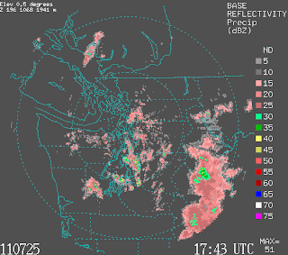
This base reflectivity graphic shows how intense the showers are. Pink and grey shades are fluff and the precipitation from those clouds are probably not reaching the ground. As you can see the Central Sound in the most part is precip free. So New Jordan, if you want showers head southwest. Or perhaps wait 'til later this evening, the weather models are hinting on a hit or miss shower (somewhere in Seattle will be wet) coming in around 8pm.
Update 4:09 pm:
The sun is beaming through the thin clouds into the cafe! And, as I finish this sentence the rays are retreating... come back soon please :-)
Friday, April 22, 2011
The Sun and Friday
Wow what a beautiful day in Seattle. And, what a difference a day makes! Check out this visible image from 6:46pm April 21st, clouds covering all of Washington State.


Now check out today's visible image at 6:45pm; a cloud free Washington. The visible satellite also shows snow covered grounds. Looks likes we'll have water for the summer :)
For tonight, after a long week of midterms and more midterms to come I think today is an appropriate time for a nighttime excursion on Capital Hill. With a clear night this weather bite can go out to all of Western Washington, cool now and cooler later :)...calm to light winds from the North with the Capital Hill Area starting in the upper 40s and later after last call.. dipping to the low 40s, grab a jacket or drink up. And, tomorrow the NWS and KOMO are throwing numbers in the mid 60s. Make it a great weekend as we return to pockets of rain, pockets of sun, and cool all around next week.
Thursday, April 21, 2011
The Weather of the Pacific Northwest by Cliff Mass

Subscribe to:
Posts (Atom)